
A rare and intensifying September nor’easter tracks toward Southern New England. It brings a multi-day hazard matrix featuring hurricane-force wind potential, heavy rainfall, and severe coastal flooding. An intensifying low-pressure system off the Virginia coast drives this severe weather event. This system pushes onshore winds against a massive high-pressure system positioned to the north. This meteorological block stalls the storm’s progression. It traps the center of circulation just south of Long Island before it eventually tracks across Southeastern Massachusetts and Rhode Island. Weather authorities from the National Weather Service warn that residents across coastal communities, the Cape and Islands, and inland zones must prepare for significant infrastructure disruptions. The storm ramps up its impacts starting Friday afternoon, with conditions escalating severely through Saturday and persisting into Sunday before gradually improving late in the weekend.
- Understanding the September Nor’easter Threat in Southern New England
- Meteorological Mechanics: Why This September Nor’easter is Rare
- Timeline of Impacts: From Mid-Week Buildup to Weekend Peak
- Rainfall Totals and Inland Flood Hazards
- Projected Accumulations in Southeastern Massachusetts and Rhode Island
- Highway Safety and Hydroplaning Risks
- Coastal Flooding, Storm Surge, and Beach Erosion
- Wave Action and Marine Hazards
- Dune Scarping and Infrastructure Inundation
- Wind Damage and Infrastructure Vulnerability
- Foliage Retention and Tree Hazard Dynamics
- Electrical Grid Strains and Power Outages
- Economic and Community Disruptions Across the Region
- Event Postponements and Municipal Closures
- Marine Industries and Ferry Service Halts
- Comparative Track Scenarios and Forecast Uncertainty
- The Inland Track: Worst-Case for Boston
- The Southern and Offshore Track Scenarios
- Actionable Emergency Preparedness Guidelines
- Securing Property and Power Backup Plans
- Travel Safety and Emergency Supplies
- Frequently Asked Questions
- Why is this nor’easter considered unusual for September?
- What are the expected peak wind speeds in Southern New England?
- How much rain will fall during the storm?
- When will weather conditions begin to improve?
Understanding the September Nor’easter Threat in Southern New England
An intensifying low-pressure system off the Virginia coast collides with a northern high-pressure block, creating a stagnant atmospheric traffic jam. This interaction channels tremendous Atlantic moisture directly into the coastal shelf of the northeast.
Communities from the mid-Atlantic up through the Gulf of Maine feel the initial pinch of this tightening pressure gradient. The prolonged duration of the event amplifies the overall threat profile. This turns a standard autumn rainstorm into a prolonged meteorological endurance test for millions of residents.
Meteorological Mechanics: Why This September Nor’easter is Rare
- Contrast with typical winter nor’easters that rely entirely on cold polar air masses
- Role of elevated late-summer sea surface temperatures supplying tropical moisture and latent heat
- Impact of the northern blocking high-pressure system locking the low-pressure center in place
Nor’easters typically strike during the deep fall and winter months when cold polar air collides aggressively with warm Atlantic moisture. Developing a full-blown nor’easter with tropical-storm-like characteristics in September is unusual. Sea surface temperatures remain elevated at the end of summer, providing additional thermal energy that fuels the intensification of the low-pressure system off the Mid-Atlantic coast.
The positioning of the blocking high-pressure system to the north creates a tight pressure gradient. This gradient forces sustained northeasterly gales across the offshore and coastal waters. As the system stalls south of Long Island, it locks persistent onshore winds into place across multiple high-tide cycles, preventing normal drainage in back bays and low-lying coastal areas.
Timeline of Impacts: From Mid-Week Buildup to Weekend Peak
- Wednesday to Thursday: Initial coastal flood risks and marine warnings along the coast
- Friday Afternoon: Steady rainfall reaches Southern New England and winds start climbing
- Friday Night to Saturday: Peak intensity with destructive wind gusts and heavy downpours
- Sunday: Tapering conditions and lingering high surf along vulnerable shorelines
The progression of the storm follows a multi-day timeline, escalating from minor tidal anomalies into destructive winds and torrential rainfall. Wednesday through Thursday brought initial coastal flood risks northward into the New Jersey shore and Delaware, alongside gale warnings for local marine waters.
By Friday afternoon, the leading edge of steady rainfall reached Southern New England. Winds began climbing steadily, and marine conditions deteriorated rapidly with seas building up to 15 feet. Friday night into Saturday marked the peak in intensity, before conditions gradually begin improving on Sunday from west to east.
Rainfall Totals and Inland Flood Hazards
Heavy rainfall is a primary concern as rich tropical moisture streams into the region. Precipitation amounts vary based on the exact wobble of the low-pressure center, but computer models project significant rainfall totals across the affected zones.
Because the region experienced a relatively dry week preceding the event, initial flash flood risks remain localized, but the sheer volume of water creates severe urban and poor-drainage flooding. Municipal workers work around the clock to clear storm drains of fallen leaves and debris.
Projected Accumulations in Southeastern Massachusetts and Rhode Island
- Four to eight inches of rain over a prolonged 48-hour window
- Severe urban and poor-drainage flooding risks in low-lying intersections
Southeastern Massachusetts and parts of Rhode Island face the highest risk, with predicted rainfall accumulations ranging between four and eight inches over a prolonged 48-hour window. Small streams and rivers in these zones are expected to reach bankfull status, with a few spots potentially touching minor flood stage.
Basement flooding becomes a significant issue for homeowners in older neighborhoods with outdated municipal drainage infrastructure. Sump pumps run continuously, and residents in flood-prone basements should elevate valuable items off the floor.
Highway Safety and Hydroplaning Risks
- Standing water hazards on major routes including Interstate 95 and Route 3
- Reduced visibility from intense wind-driven spray and heavy downpours
Motorists face high risks of hydroplaning on major highways, including sections of Interstate 95, due to standing water and intense spray from high winds. Law enforcement agencies strongly urge drivers to avoid non-essential travel during the peak rainfall rates on Friday night and Saturday.
Ponding on roadways develops rapidly during intense rain bands. Drivers should reduce speeds significantly, increase following distances, and never attempt to drive through flooded roadways where the depth of the water is unknown.
Coastal Flooding, Storm Surge, and Beach Erosion
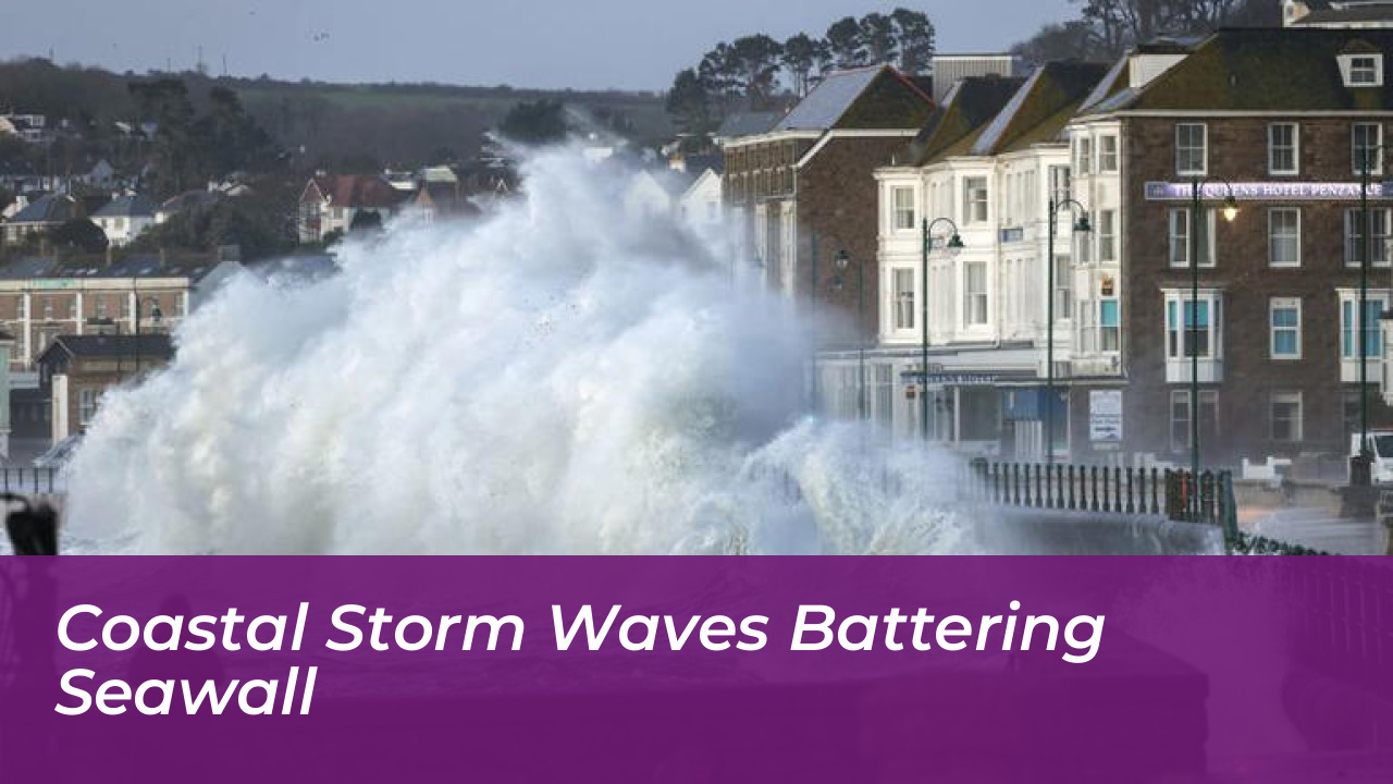
Coastal communities face significant dangers from storm surge, astronomical high tides, and pounding wave action. The persistent northeasterly fetch pushes millions of gallons of water against the coastline, trapping water in estuaries and low-lying coastal roads.
Tidal anomalies run two to three feet above normal astronomical predictions during peak high tide cycles. This combination forces seawater over sea walls and into vulnerable beach parking lots and coastal neighborhoods.
Wave Action and Marine Hazards
- Offshore seas reaching towering heights of 20 to 25 feet
- Battering waves along outer Cape and Nantucket shores of 12 to 15 feet
Offshore marine waters experience towering seas of 20 to 25 feet, creating extremely hazardous conditions for any vessel daring to venture out. Outer Cape and Nantucket shores face battering waves of 12 to 15 feet that tear at the shoreline.
Commercial fishing fleets and recreational boaters have secured their vessels in port, recognizing the extreme danger of open water navigation during this intense marine event. Harbor masters report zero active vessel movement in high-risk sounds.
Dune Scarping and Infrastructure Inundation
- Continuous wave action across multiple high-tide cycles accelerating erosion
- Threats to oceanfront infrastructure, boardwalks, and low-lying coastal roads
- Moderate to major flooding in Boston Harbor, Plymouth, and Rhode Island
Continuous wave action across multiple high-tide cycles accelerates beach erosion, threatening oceanfront infrastructure, boardwalks, and vulnerable coastal roadways. Dune scarping leaves exposed sand cliffs along many popular beaches.
Boston Harbor, Plymouth, and low-lying areas of Rhode Island face moderate to major coastal flooding during peak high tides. Seawater inundates coastal access roads, temporarily isolating certain beach communities until waters recede.
Wind Damage and Infrastructure Vulnerability
High winds present the most widespread threat to inland and coastal properties alike. Because deciduous trees retain their full summer foliage in late September, their canopies act as massive sails against the driving gale.
Heavy rain adds excessive weight to the upper branches, making trees top-heavy and exceptionally prone to snapping or uprooting. Saturated soils further compromise root systems, allowing strong gusts to push over mature trees.
Foliage Retention and Tree Hazard Dynamics
- Full summer canopies acting as wind sails in late September
- Excessive weight from heavy rain making trees prone to snapping
Trees holding their full green leaves catch significantly more wind force than barren winter trees. This extra aerodynamic drag places immense mechanical stress on the trunk and primary structural roots.
When combined with soil softening from four to eight inches of rain, root plates easily fail. Property owners should inspect trees near structures and move vehicles away from large overhanging branches before winds peak.
Electrical Grid Strains and Power Outages
- Utility crew mobilizations ahead of the weekend across the entire region
- Sustained gales and gusts between 50 and 70 mph snapping poles
Utility companies across Southern New England mobilized repair crews ahead of the weekend, anticipating widespread power outages. Sustained winds combined with frequent gusts between 50 and 70 mph will strain electrical grids, snap utility poles, and bring down tree limbs onto power lines.
Restoration efforts may face delays while sustained winds remain above safe bucket-truck operating thresholds. Residents should prepare for multi-day power outages, particularly in heavily wooded suburban towns.
Economic and Community Disruptions Across the Region
The severity of the weekend forecast forced widespread cancellations and postponements of major cultural, athletic, and municipal events across New England and Long Island.
Organizers of the Greenport Maritime Festival and other regional autumn fairs postponed their major weekend events to mid-October. Local athletic schedules, outdoor music festivals, and agricultural events activated rain dates to ensure public safety.
Event Postponements and Municipal Closures
- Rescheduling of major cultural, agricultural, and maritime festivals
- Activation of rain dates for high school and collegiate athletic schedules
Municipal parks, hiking trails, and coastal recreation areas closed to the public ahead of Friday afternoon. Public safety officials want to keep sightseers away from dangerous surf zones and unstable tree lines.
Local businesses in tourist-heavy coastal towns report significant revenue losses as weekend bookings are canceled en masse. Restaurants and hotels process numerous cancellations as visitors heed weather warnings.
Marine Industries and Ferry Service Halts
- Commercial fishing fleets and recreational vessels securely tied down in port
- Rolling cancellations for Martha’s Vineyard and Nantucket ferry services
Marine industries face severe disruptions as commercial fishing fleets and recreational boaters secure vessels in port. Dock masters double-check mooring lines and secure marina equipment.
Ferry services operating between the mainland and Martha’s Vineyard, Nantucket, and Block Island face rolling cancellations due to dangerous sea states and gale-force winds. Passengers are advised to check operational status before traveling to ports.
Comparative Track Scenarios and Forecast Uncertainty
Meteorologists analyzing ensemble computer models highlight three primary track scenarios for the low-pressure center. Each track produces significantly different impact profiles for major metropolitan hubs.
Small variations in steering currents aloft create substantial shifts in the forecast cone. Forecasters continuously update guidance as reconnaissance aircraft gather real-time atmospheric data from the storm center.
The Inland Track: Worst-Case for Boston
- Direct track over or just inland of Boston
- 60 to 70 mph wind gusts and major storm surge across the harbor
If the low tracks directly over or just inland of Boston, the region experiences peak intensity with 60 to 70 mph wind gusts, major storm surge, and severe structural disruptions. This scenario maximizes wind damage and urban coastal flooding.
Power outages under this worst-case track would be extensive, affecting hundreds of thousands of utility customers. Transportation networks would experience severe gridlock and systemic delays.
The Southern and Offshore Track Scenarios
- Shifting impacts toward New York City and Long Island under southern tracks
- Least likely offshore track keeping major impacts confined over open ocean waters
If the system tracks further south, the heaviest rain and strongest winds shift away from Boston, placing New York City and Long Island on the northern fringe of the impacts. Coastal New Jersey also absorbs heavier surge values.
In the least likely offshore track scenario, the low-pressure center remains out to sea. Southern New England experiences only breezy conditions and elevated tides, while major impacts remain displaced over open ocean waters.
Actionable Emergency Preparedness Guidelines
Residents living in flood-prone zones, coastal communities, and heavily wooded neighborhoods must take immediate precautions to safeguard life and property.
Preparation done before the storm hits prevents costly property damage and reduces personal injury risks. Keep emergency kits accessible and maintain open lines of communication with family members.
Securing Property and Power Backup Plans
- Securing outdoor patio furniture, trash bins, and seasonal decorations
- Charging mobile devices, power banks, and backup medical equipment
Secure all outdoor patio furniture, planters, and trash bins that could become dangerous projectiles in 60 mph gusts. Bring potted plants indoors and anchor temporary outdoor structures.
Charge mobile devices, portable power banks, and essential medical equipment immediately. Test home backup generators, ensure you have sufficient fuel stored safely, and review family evacuation plans.
Travel Safety and Emergency Supplies
- Avoiding flooded roadways and high-risk coastal zones completely
- Stockpiling potable water, non-perishable food, and NOAA weather radios
Stockpile at least three days of potable water, non-perishable food items, and a reliable battery-powered or hand-crank NOAA weather radio. Keep flashlights and extra batteries in easily accessible locations.
Stay off the roads once the heavy rain and winds begin. Never drive around barricades blocking flooded streets, as roadbeds may be washed away beneath the murky water. Stay tuned to local news broadcasts and review official evacuation guidelines issued by municipal authorities.
Frequently Asked Questions
Why is this nor’easter considered unusual for September?
A typical nor’easter develops in deep winter when cold polar air crashes against warm Atlantic currents. This September storm draws power from unusually warm late-summer sea surface temperatures, combining tropical moisture characteristics with traditional winter storm dynamics.
What are the expected peak wind speeds in Southern New England?
Inland areas can expect wind gusts between 35 and 45 mph. However, outer coastal zones, Boston Harbor, Plymouth, and the islands experience much stronger destructive gusts ranging from 50 to 70 mph.
How much rain will fall during the storm?
Southeastern Massachusetts and parts of Rhode Island face the highest precipitation totals, with computer models projecting between four and eight inches of rain over a prolonged 48-hour window.
When will weather conditions begin to improve?
Weather conditions gradually improve from west to east across the region late Sunday. Lingering high surf and beach erosion may persist into Monday morning before ocean swells finally subside.